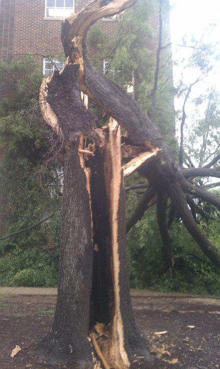
Please pray for the people of Tuscaloosa. It is hell here. Here is our video of the tornado.
Thursday, April 28, 2011
Wednesday, April 27, 2011
NEW TORNADO COMING TOWARDS TUSCALOOSA METRO AND UA CAMPUS
THE NATIONAL WEATHER SERVICE IN BIRMINGHAM HAS ISSUED A
* TORNADO WARNING FOR... NORTHERN GREENE COUNTY IN WEST CENTRAL ALABAMA... NORTHWESTERN HALE COUNTY IN WEST CENTRAL ALABAMA... SOUTHERN PICKENS COUNTY IN WEST CENTRAL ALABAMA... NORTH CENTRAL SUMTER COUNTY IN WEST CENTRAL ALABAMA... SOUTHWESTERN TUSCALOOSA COUNTY IN WEST CENTRAL ALABAMA...
* UNTIL 445 PM CDT
* AT 333 PM CDT... THE NATIONAL WEATHER SERVICE INDICATED A SEVERE THUNDERSTORM CAPABLE OF PRODUCING A TORNADO. THIS DANGEROUS STORM WAS LOCATED 15 MILES WEST OF EMELLE... OR 26 MILES NORTHWEST OF YORK... AND MOVING NORTHEAST AT 55 MPH.
* THIS DANGEROUS STORM WILL BE NEAR... WEST UNION AROUND 350 PM CDT. PANOLA AROUND 355 PM CDT. NEW WEST GREENE AND WEST GREENE AROUND 405 PM CDT. MANTUA... BENEVOLA AND UNION AROUND 420 PM CDT. JENA AROUND 425 PM CDT. COKER AROUND 440 PM CDT. BRYANT DENNY STADIUM AROUND 445 PM CDT.
OTHER LOCATIONS IMPACTED BY THIS DANGEROUS STORM INCLUDE GEIGER... WARSAW... PLEASANT RIDGE... LEWISTON... SNODDY... PIONEER... RALPH... ROMULUS... FOSTERS AND FOSTERS BOAT LANDING.
PRECAUTIONARY/PREPAREDNESS ACTIONS...
TAKE COVER NOW. FOR YOUR PROTECTION MOVE TO AN INTERIOR ROOM ON THE LOWEST FLOOR OF A STURDY BUILDING.
&&
TO REPORT SEVERE WEATHER... CALL 1-800-856-0758.
TORNADO WARNING PICKENS AND TUSCALOOSA COUNTIES
THE NATIONAL WEATHER SERVICE IN BIRMINGHAM HAS ISSUED A
* TORNADO WARNING FOR... PICKENS COUNTY IN WEST CENTRAL ALABAMA... WEST CENTRAL TUSCALOOSA COUNTY IN WEST CENTRAL ALABAMA...
* UNTIL 415 PM CDT
* AT 310 PM CDT... THE NATIONAL WEATHER SERVICE WAS TRACKING A CONFIRMED TORNADO 16 MILES WEST OF MEMPHIS... OR 20 MILES SOUTHWEST OF PICKENSVILLE. DOPPLER RADAR SHOWED THIS TORNADO MOVING NORTHEAST AT 50 MPH.
* THE TORNADO WILL BE NEAR... PICKENSVILLE AROUND 335 PM CDT. ETHELSVILLE AND CARROLLTON AROUND 345 PM CDT. REFORM AROUND 355 PM CDT. ASHCRAFT CORNER AROUND 410 PM CDT.
OTHER LOCATIONS IMPACTED BY THE TORNADO INCLUDE PINE GROVE... MCSHAN... OWENS... NORTH PICKENS AIRPORT... LUBBUB AND MOORES BRIDGE.
PRECAUTIONARY/PREPAREDNESS ACTIONS...
TAKE COVER NOW. FOR YOUR PROTECTION MOVE TO AN INTERIOR ROOM ON THE LOWEST FLOOR OF A STURDY BUILDING.
&&
TO REPORT SEVERE WEATHER... CALL 1-800-856-0758


STORM PREDICTION CENTER HAS ELEVATED MUCH OF NORTH/CENTRAL ALABAMA TO A HIGH RISK OF SEVERE WEATHER TODAY
Here is what our friend, Jason Simpson, has to say about it:

-Jason
Twitter: @simpson3340
Facebook: Jason Michael Simpson
High Risk Includes North and Central Alabama
A very long day is getting ready to begin. A line of severe storms is nearing I 55 in Central Mississippi this morning; that will likely be the first round of many for Alabama today. Stay with us throughout the day and into the night as this situation develops. Unfortunately, we cannot pinpoint single communities for storm time arrival, and we also cannot determine if a tornado, wind gust, or large hail will hit a particular area. The forecast is for a broad area of strong to severe storms over the entire state today with the greatest threat for tornadoes, wind, and hail in the HIGH risk area labeled below by the Storm Prediction Center:
AN OUTBREAK OF TORNADOES AND DAMAGING WINDS IS EXPECTED TODAYThis has the potential to out-do the April 15th outbreak, so be alert today. Follow us on Facebook and Twitter if you can’t be near the blog or the TV for ABC 33/40′s coverage.
THROUGH EVENING OVER PORTIONS OF NRN MS…NRN AL…TN AND KY
-Jason
Twitter: @simpson3340
Facebook: Jason Michael Simpson
Monday, April 25, 2011
Weather Outlook for 4/25/11 *SEVERE WEATHER POSSIBLE 4/26-4/27*
Hello out there. My apologies for neglecting the blog these past few days, but the weather has been rather uneventful, but that will soon change. Welcome to April in Alabama. Here are the details.
CURRENT OBSERVATIONS(AS OF 1600)
TEMP: 82*F
Mostly Sunny, Warm and Muggy
Wind out of the South at 13MPH gusting to 22MPH
TUESDAY 4/26/2011
High of 80*F, Low of 69*F
Scattered Thunderstorms throughout the day, mainly in the afternoon/evening hours. Take an umbrella with you to class just to err on the side of caution. Not expecting anything too severe tomorrow, but as I mentioned earlier, it's April in Alabama, anything can happen. The main threat rolls in here Wednesday afternoon.
WEDNESDAY 4/27/2011
Here we go again. The SPC out of Norman, OK has us under a moderate risk of severe weather Wednesday afternoon. There's a 50/50 chance of severe weather within 25 miles of a given point within this moderate area. Expect a high of 83*F, Low of 50*F. Rain, wind, hail at times. You name it. I don't want to say whether or not UA will cancel classes simply because we at UAMS have nothing to do with their decision making process for cancelling, plus it's "Dead Week", but I'm willing to bet some classes will be suspended until the warnings expire. The word "outbreak" has been tossed around by weather officionados regarding Wednesday's events, so take it however you'd like. Most likely we'll have a crew at the TuscCo EMA office once watches come out, and we'll have our new crew out in the field with the hopes of intercepting the incoming storms. Either way, we'll be bringing you updates throughout the day tomorrow and Wednesday. Make sure you have a severe weather plan in place should our area become threatened.
Follow us on Twitter www.twitter.com/UAMS1
I'll bring more updates as the models become updated.
Until next time, Sub Divo!
PAR
Wednesday, April 20, 2011
Damage Reports Already Coming out of Tuscaloosa
Jason Simspon's post on the alabamawx.com blog!"A severe thunderstorm has caused some big issues in the City of Tuscaloosa this morning. Trees, power lines, and traffic lights are down all over town. A large tree is blocking Lurleen B. Wallace southbound, and TPD has traffic rerouting at University. Power is out to parts of the UA Campus and the Highlands neighborhood near DCH Hospital. Here is one photo of a tree through a house:

Winds gusted to 74 miles per hour at our Skycam on top of the Tuscaloosa County Courthouse. The severe storm is still packing a punch as it moves into Bibb and eventually Shelby County. Be prepared for 60 to 80 mile per hour winds. Falling trees are one of the biggest dangers you will find in storms like this, so stay away from windows, porches, and outside walls. Protect yourself in the middle of the building, and wait until the storm has passed before you venture outside.
-Jason
Follow me on Twitter: @simpson3340"
Weather Outlook for 4/20/2011
We've gotten off to a wet and wild start this morning. I am currently drenched as I walked to my 9 o'clock class, however, I did remember a raincoat this time :) Students, be sure to watch the weather throughout the day today. We're not expecting anything severe like last Friday. However, strong, straight line winds, heavy downpours, and frequent lightning are the weapons today. We'll keep you posted here if something severe breaks out.
CURRENT OBSERVATIONS
TEMP: 72*F
Raining heavily at the moment, lightning frequently, steady breeze
Dewpoint: 66*
THROUGHOUT THE DAY
Severe Thunderstorm watch in effect for Tuscaloosa County until 10am CDT. Some more storms should fire up this afternoon, but the atmosphere lacks the helicity to create a tornado threat similar to last week.
REST OF THE WEEK
Scattered thunderstorms throughout the rest of the day today, and most of tomorrow. Drying up on Good Friday and will be dry, and humid, for Easter weekend. Mr. Spann has said that Easter will be comparable to the Fourth of July.
Follow us on Twitter! www.twitter.com/UAMS1
PAR
Sunday, April 17, 2011
Saturday, April 16, 2011
Friday, April 15, 2011
VIDEO OF THE TUSCALOOSA TORNADO 4/15/11
Here is video of the tornado that came through southern Tuscaloosa county today. We do not take credit for this video http://yfrog.com/nsgk6z
Numerous damage reports coming from south of town and the Skyland Blvd, HWY 82, Hargrove Road areas.
Stay off the roads. Yield to Emergency vehicles.
Flooding in the streets near Tutwiler Hall/south end of Bryant-Denny Stadium.
Stay tuned for more updates.
www.twitter.com/UAMS1 http://www.alabamawx.com/ http://www.bamawx.com/
PAR
3 SIMULTANEOUS TORNADO WARNINGS FOR TUSCALOOSA COUNTY
TAKE SHELTER IMMEDIATELY. ALL OF TUSCALOOSA COUNTY IS UNDER THE GUN AT THIS MOMENT. THERE ARE THREE SIMULTANEOUS TORNADO WARNING POLYGONS ACTIVE FOR THE COUNTY.
www.twitter.com/UAMS1 http://www.alabamawx.com/ http://www.bamawx.com/
PAR
www.twitter.com/UAMS1 http://www.alabamawx.com/ http://www.bamawx.com/
PAR
TORNADO WARNING FOR TUSCALOOSA COUNTY 4/15/11
THE NATIONAL WEATHER SERVICE IN BIRMINGHAM HAS ISSUED A
* TORNADO WARNING FOR... EAST CENTRAL GREENE COUNTY IN WEST CENTRAL ALABAMA... NORTHERN HALE COUNTY IN WEST CENTRAL ALABAMA... SOUTHERN TUSCALOOSA COUNTY IN WEST CENTRAL ALABAMA...
* UNTIL 315 PM CDT
* AT 220 PM CDT... STORM SPOTTERS AND THE NATIONAL WEATHER SERVICE WERE TRACKING A LARGE AND EXTREMELY DANGEROUS TORNADO NEAR WEST GREENE... OR 10 MILES NORTHWEST OF EUTAW. DOPPLER RADAR SHOWED THIS TORNADO MOVING EAST AT 35 MPH.
... TORNADO EMERGENCY FOR UNION... KNOXVILLE... RALPH... AND MOUNDVILLE. TAKE COVER NOW. STORMS REPORTS OF A ONE HALF OF A MILE WIDE TORNADO...
* LOCATIONS IMPACTED INCLUDE... UNION... KNOXVILLE... MOUNDVILLE... MCFARLAND MALL... LAKE WILDWOOD... COALING... SNODDY... RALPH... FOSTERS AND MOUNDVILLE AIRPORT.
THIS INCLUDES... INTERSTATE 20 EXIT NUMBERS 45 THROUGH 79...
PRECAUTIONARY/PREPAREDNESS ACTIONS...
TO REPEAT... A LARGE... EXTREMELY DANGEROUS AND POTENTIALLY DEADLY TORNADO IS ON THE GROUND. TO PROTECT YOUR LIFE... TAKE COVER NOW. FOR YOUR PROTECTION MOVE TO AN INTERIOR ROOM ON THE LOWEST FLOOR OF A STURDY BUILDING.
&&
TO REPORT SEVERE WEATHER... CALL 1-800-856-0758.
ROTATING STORM COMING OUT OF MS COMING TOWARDS TUSCALOOSA
WE ARE CURRENTLY AT THE TUSC CO EMA OFFICE MONITORING A STORM COMING OUT OF MISSISSIPPI. THE SUPERCELL WILL EFFECT SUMTER, GREENE, AND SOUTH PICKENS COUNTY, AND TUSCALOOSA COUNTY. THIS STORM IS SHOWING DEFINITE SIGNS OF ROTATION AND HAIL. WILL EFFECT TUSCALOOSA WITHIN 45 MINUTES. GET READY!
STAY CLOSE TO WEATHER UPDATES!
www.twitter.com/UAMS1 http://www.uamswx.blogspot.com/ http://www.alabamawx.com/
PAR
STAY CLOSE TO WEATHER UPDATES!
www.twitter.com/UAMS1 http://www.uamswx.blogspot.com/ http://www.alabamawx.com/
PAR
DAMAGE REPORTS COMING OUT OF MISSISSIPPI
THE TWITTER WAVES ARE FILLED WITH DAMAGE REPORTS POURING OUT OF JACKSON, MS AND CLINTON, MS. THESE STORMS ARE INTENSIFYING. ONE DEFINITE TOUCHDOWN OF A HUGE TORNADO! WEST ALABAMA, GET READY BECAUSE THE TRAIN IS COMING. STAY TUNED TO WEATHER UPDATES THROUGHOUT THE DAY. WE ARE HEADING TO TUSC CO EMA SHORTLY AND WILL BE UPDATING YOU FROM THERE.
WWW.TWITTER.COM/UAMS1 http://www.alabamawx.com/ http://www.bamawx.com/
PAR
WWW.TWITTER.COM/UAMS1 http://www.alabamawx.com/ http://www.bamawx.com/
PAR
FRIDAY 4/15/11 UPDATE AT 1048
We are currently under a tornado watch until 3pm. Storms will begin rolling in within the next couple of hours. Nothing to impressive just yet, but that's not to say we won't have issues in a short while. 2 reported fatalities with this system in Oklahoma yesterday evening. Stick close to weather information throughout the day.
www.twitter.com/UAMS1 http://www.alabamawx.com/ http://www.bamawx.com/
http://www.weather.com/weather/today/Tuscaloosa+AL+35401
PAR
www.twitter.com/UAMS1 http://www.alabamawx.com/ http://www.bamawx.com/
http://www.weather.com/weather/today/Tuscaloosa+AL+35401
PAR
Thursday, April 14, 2011
Weather Outlook for 4/14/2011 & SEVERE WEATHER UPDATE FOR TOMORROW
Well, what we feared may happen Friday is looking more and more like a certainty with each passing hour. The NWS is expecting a "tornado outbreak" similar to those you only hear about from "old-timers". Here in West Alabama we've been fortunate over the past decade or so by not having to deal with an outbreak scenario. All of us who have been in Tuscaloosa for quite some time remember the catastrophic F-4 Tornado that wreaked havoc in the Hillcrest/Taylorville/Bear Creek area on December 16, 2000. There were numerous fatalities, injuries and unfathomable property damage. Those who lived through it will never forget that day. (Note: I'm aware that there have been other tornadoes that have been as catastrophic, if not more, as the Dec. 16th tornado). Here's the link to the footage from our friends at ABC 33/40 of that fateful day:
All that being said, I hope and pray that you will take tomorrow seriously. We are being faced with another grave weather outbreak.
CURRENT OBSERVATIONS(AS OF 1400)
Temp: 77*F
Sunny
Wind: SSE ~6MPH
Dew Point: 47*
TOMORROW(FRIDAY 4/15/11)

All that being said, I hope and pray that you will take tomorrow seriously. We are being faced with another grave weather outbreak.
CURRENT OBSERVATIONS(AS OF 1400)
Temp: 77*F
Sunny
Wind: SSE ~6MPH
Dew Point: 47*
TOMORROW(FRIDAY 4/15/11)
SEVERE WEATHER IS EXPECTED. STRONG TORNADOES, HAIL, DAMAGING STRAIGHT LINE WINDS, HEAVY RAINFALL ARE ALL EXPECTED. There is a Sugarland Concert on tap for tomorrow evening at the New Tuscaloosa Ampitheater and it's race weekend at Talladega Superspeedway in East Alabama. Now, the Sugarland Concert will most likely be rescheduled due to the incoming severe weather. You can check here for updates: http://twitter.com/#!/TuscaloosaAmp The race on Saturday should go on as planned contingent on track conditions. The main concern is for the large number of people camping outside the track. If you're heading out to Talladega, please insure that you have somewhere to go should severe weather threaten the area. It's also A-Day weekend for UA, so there will be a lot of people in town for those activities starting tomorrow. Make sure you have access to up to date weather information throughout the day tomorrow. Current models are showing that storms could begin firing up in West Alabama as early as 10am, then the main squall line is set to come through between the hours of 3PM and 6PM. Strong Tornadoes are a threat throughout the day tomorrow. Make sure you are watching the weather and planning accordingly. Here is the NWS prediction graphic for Tornadoes with tomorrow's system:

Our crew will be at the Tuscaloosa County EMA office tomorrow as soon as a watch is issued for our area. We will be bringing you updates as soon as they are made available. Tune into our Twitter account at www.twitter.com/UAMS1 or pay attention to this blog.
If you have any questions, comments, or concerns, please email us at bamauams@yahoo.com or call 205-347-5664 and leave a message with your name and number and one of us will return your email or call ASAP.
Stay safe!
PAR
Wednesday, April 13, 2011
ELEVATED SEVERE WEATHER RISK FRIDAY (4/15/2011)
The NWS has raised the risk of severe weather this Friday (4/15/11). We previously thought this would simply be another straight line wind event; however, as weather always does, this has changed. We are now faced with another tornado "outbreak". Here's a pictoral explanation of the factors in place leading to our storms on Friday:


As noted on the image, tornadoes, locally heavy rain, hail, damaging winds all are to be expected with this event Friday. Now is the time to review your severe weather plan. If you don't have one, maybe you should consider creating one. Remember, the safest place to be during a tornado is the lowest floor in the sturdiest building available, closest to the middle of the building (the more walls between you and outside, the better), stay away from windows and items that can conduct electricity if struck by lightening. Blankets/comforters and pillows have proven to be a useful means of protecting yourself against debris. Make sure you have items at your disposal should disaster strike. These include canned foods, water, batteries, duct tape, flashlights, radio or portable and battery operated television, cell phone, first-aid kit, etc.
BOTTOM LINE
Storms should ramp up in the mid afternoon hours and last throughout the evening. Rain should begin around noon. Currently there are two different scenarios in place: either the squall line will come through bringing mostly straight line winds, heavy rain, and a few tornadoes; or cells could develop ahead of the squall line which could be disastrous, then, to ice the cake, the squall line will come through with heavy rain, straight line winds, and a few tornadoes. Either way, we're looking at a serious, healthy storm system that will come through our area on Friday afternoon. Look out!
It is IMPERATIVE that you stay close to weather updates throughout the day Friday, and have a plan in place should disaster strike. We'll update this blog tomorrow midday when we should know a little better the specifics about Friday's weather event.
Follow us on Twitter at www.twitter.com/UAMS1 for up to date weather updates, or visit this blog often! Bookmark us!
We'll be at the Tuscaloosa County EMA(EOC) office Friday throughout the weather event bringing you live updates as they happen!
Stay tuned, and safe!
PAR
Weather Outlook for 4/13/11
Got off to a cool start this morning. However, it has warmed up nicely this afternoon. Expect this warming trend to continue through Friday, when we're set for another cold front to come through.
CURRENT OBSERVATIONS (AS OF 1330)
Sunny
Temp: 75*F
Wind: from the ENE ~4mph
Humidity: 34%
Dew Point: 44*
REST OF THE WEEK
Mostly sunny the rest of the week. Warmer on Thursday with a high of 83*F. Another front is set to move through Friday. We'll experience scattered thunderstorms. As of right now, we're not expecting anything severe. Winds might be a risk, but we'll know more tomorrow.
SATURDAY-(A-DAY GAME)
Noticeably cooler. High of 71*F. Mostly sunny. Should be perfect weather for UA's Spring Football game. Check out http://www.rolltide.com/ for more info on the A-Day events!
Yesterday, I had the privilege of speaking with Mayor Maddox and Tuscaloosa County EMA Director, David Hartin, about our Society. I want to acknowledge our appreciation of their support! Mr. Hartin invited UAMS to join him and the TuscCo EMA in the EMA office next time severe weather threatens our area! We are extremely excited about this opportunity and look forward to further interaction between our organizations!
Check us out on Twitter for up to the moment weather related news! www.twitter.com/UAMS1
Want to know more about UAMS? Send us an email to bamauams@yahoo.com or check us out on Facebook("University of Alabama Meteorological Society")
Sub Divo!
PAR
Tuesday, April 12, 2011
Weather Outlook for 4/12/11
We appear to have dodged the bullet last night as places like Aliceville, Fayette, Jasper, Curry, Bluff Park, and Vestavia Hills will be getting a visit from the NWS Storm Survey teams. Wind was the weapon last night. No signs of a tornado touchdown anywhere in West Alabama. Read on...
CURRENT OBSERVATIONS(AS OF 0830)
56*F, Sunny, Wind NW~5mph
REST OF THE DAY(TUESDAY)
High of 75*F, Sunny, 0% chance of precipitation, Wind NW~13mph
REST OF THE WEEK
Gradual warming trend from today thru Thursday. Set for another cold front and round of storms to come through on Friday. Some discrepencies on the timing of the front/storms, hopefully by tomorrow or Thursday at the latest, we'll have a better timeline in place. James Spann is calling Friday's storms another wind event as opposed to a Tornadic event.
WEEKEND
Cooler start to the weekend with Saturday's high only at 68*F, with a low of 42*F; and sunny. Then Sunday we warm up just a little bit more up to 73*F, low of 54*F; mostly sunny.
Check us out on Twitter at www.twitter.com/UAMS1
or on Facebook, search "University of Alabama Meteorological Society"
PAR
Monday, April 11, 2011
Tornado Warning For Tuscaloosa County- CANCELLED
Severe weather threat for UA Campus and downtown Tuscaloosa has now come and gone. Numerous branches, limbs, porch funriture have been blown around. Jason Simpson ABC33/40 reports numerous trees down in the Sipsey Valley/Buhl area. Power is out in select areas in town. Sky now has an ominous yellow tint about it, rain is beginning to taper off, winds have died down. Noticeably cooler. Stay safe. If you have any interesting pictures or video send them to us at bamauams@yahoo.com!
And now that I'm done with this post, the rain has decided to kick back up. Gotta love Alabama wx.
PAR
And now that I'm done with this post, the rain has decided to kick back up. Gotta love Alabama wx.
PAR
TORNADO WARNING TUSCALOOSA COUNTY
THE NATIONAL WEATHER SERVICE IN BIRMINGHAM HAS ISSUED A
* TORNADO WARNING FOR... NORTH CENTRAL GREENE COUNTY IN WEST CENTRAL ALABAMA... EAST CENTRAL PICKENS COUNTY IN WEST CENTRAL ALABAMA... SOUTHERN TUSCALOOSA COUNTY IN WEST CENTRAL ALABAMA...
* UNTIL 645 PM CDT
* AT 606 PM CDT... THE NATIONAL WEATHER SERVICE INDICATED A SEVERE THUNDERSTORM CAPABLE OF PRODUCING A TORNADO. THIS DANGEROUS STORM WAS LOCATED NEAR BENEVOLA... OR 11 MILES SOUTHEAST OF CARROLLTON... AND MOVING EAST AT 55 MPH.
* LOCATIONS IMPACTED INCLUDE... NORTHPORT... TUSCALOOSA... HOLT... JENA... COKER... BRYANT DENNY STADIUM... MCFARLAND MALL... UNIVERSITY MALL... DEERLICK CREEK CAMPGROUNDS AND LAKE WILDWOOD.
THIS INCLUDES... INTERSTATE 20 EXIT NUMBERS 62 THROUGH 89...
PRECAUTIONARY/PREPAREDNESS ACTIONS...
TAKE COVER NOW. FOR YOUR PROTECTION MOVE TO AN INTERIOR ROOM ON THE LOWEST FLOOR OF A STURDY BUILDING.
&&
TO REPORT SEVERE WEATHER... CALL 1-800-856-0758.
Severe Weather Upgrade
The NWS has decided to upgrade a large part of NW Alabama to a "moderate" risk for severe weather. This is a step up from the previous classification of "slight". Parts of Tuscaloosa County, the northwestern parts of the county to be specific, are now included in this "moderate" convective outlook. It appears that now tornadoes will be more of a threat than previously forecasted.
CURRENT OBSERVATIONS
MOSTLY CLOUDY, 75*F, 73% HUMIDITY, DEWPOINT 66*, WINDS SW ~7MPH
OUTLOOK FOR THE REST OF THE DAY
HIGH OF 79*F, STRONG STORMS/SOME MAY BE SEVERE, HEAVY RAINFALL AT TIMES, DAMAGING STRAIGHT LINE WINDS, HAIL POSSIBLE, ISOLATED TORNADOES POSSIBLE ALONG THE SQUALL LINE
BOTTOM LINE
THE CAP OVER NORTHWESTERN MISSISSIPPI HAS ERODED LEADING TO STORMS FIRING UP ALONG THE COLD FRONT, A TORNADO WATCH EXISTS TO THE WEST OF US, ONE WILL MOST LIKELY BE ISSUED FOR MUCH OF ALABAMA AS THE DAY PROGRESSES.
***HAVE A SEVERE WEATHER PLAN IN PLACE, STAY CLOSE TO WEATHER INFORMATION THROUGHOUT THE DAY***
http://www.alabamawx.com/ http://www.bamawx.com/ www.twitter.com/UAMS1
PAR
Severe Weather Possibility Today (Monday 4/11/2011)
There is the potential for severe weather today, mainly this afternoon. Although, the NWS doesn't believe we'll experience many(if any) tornadoes in West Alabama, there is always the possibility for spin offs when a cold front comes through. As I'm sure you've noticed, it's been relatively warm and muggy here the past couple of days, and with a cold front set to pass through this evening, the possibility of strong storms is in place. Current observations: 72*F at 0114 with a dew point of 65*. Any time the dew point is 60* or higher, there is a risk of storms. The higher the dew point, the more severe. Our friends from ABC 33/40 in Birmingham have estimated that the squall line will reach West Alabama between the hours of 4-6pm. Those of you with morning classes tomorrow need not worry, the rain isn't supposed to reach here until the afternoon. I would venture a guess that the rain will begin around noon, and be spotty at that. The greatest chance of consistent, and potentially heavy rain will come around 3pm.
MAIN THREATS
Hail, Strong Straight-Lined Winds, minor flooding in areas prone to flooding
***Stay close to Weather resources throughout the day, especially afternoon***
alabamawx.com www.bamawx.com twitter.com/UAMS1
***UA Students, sign up for text alerts at http://prepare.ua.edu/?page_id=1700 ***
Stay safe, and keep an eye on the sky!
PAR
UP AND RUNNING!
As Founder and President of the University of Alabama Meteorological Society (UAMS), I would like to take this opportunity to welcome you to our new blog page! You can check in here for weather updates specific to the University of Alabama campus and surrounding areas! This blog will also be used to communicate amongst members of the Society, as well as to keep you, the public, updated on events and happenings in UAMS. If you're interested in joining our Society, send us an email at bamauams@yahoo.com. Follow us on Twitter for weather/group updates @UAMS1 or join our group on Facebook, just type "University of Alabama Meteorological Society" in the search bar. If you'd like to make a tax-deductible donation to UAMS send us an email! Any and All donations are certainly welcomed and greatly appreciated!
Thanks for checking us out!
Patrick Alan Reilly
"May the road rise to meet you.
May the wind be always at your back.
May the sun shine warm upon your face.
And rains fall soft upon your fields.
And until we meet again,
May God hold you in the hollow of His hand.
May you live as long as you want,
And never want as long as you live.
Always remember to forget
The things that made you sad.
But never forget to remember
The things that made you glad.
Always remember to forget
The friends that proved untrue.
But never forget to remember
Those that have stuck by you.
Always remember to forget
The troubles that passed away.
But never forget to remember
The blessings that come each day..." -Excerpt from an Irish Blessing
Subscribe to:
Posts (Atom)